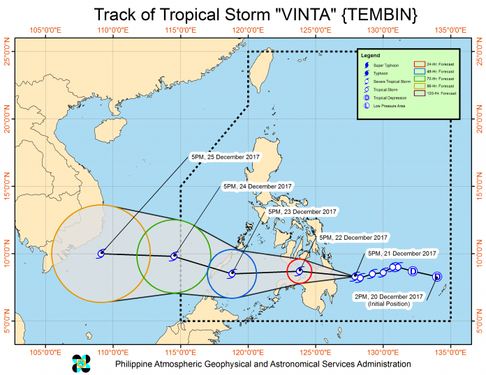
Tropical depression ‘Vinta’ is expected to make landfall “over Caraga – Davao Region” between Thursday evening (December 21) and Friday morning (December 22), according to Severe Weather Bulletin 2 issued by the Philippine Atmospheric, Geophysical and Astronomical Services Administration (PAGASA) issued at 11 p.m. Wednesday.
Vinta, the weather bulletin said, “has slightly intensified as it moves westward over the Philippine Sea” and Tropical Cyclone Warning Signal number 1 has been raised over Surigao del Norte, Surigao del Sur, Agusan del Norte, Agusan del Sur, Davao del Norte, Compostela Valley, and northern Davao Oriental,
But the weather bulletin also cited “possible inclusion” of the provinces of Dinagat Islands, Camiguin, Misamis Oriental, and Bukidon “in areas under Tropical Cyclone Warning Signal No. 1 within six hours.”
Davao Oriental Governor Nelson Dayanghirang activated its Incident Command System (ICS) Wednesday afternoon during an emergency meeting of the Provincial Disaster Risk Reduction and Management Council (PDRRMC) as the province braces for “serious flooding” in low-lying areas.
Baganga in the northern part of Davao Oriental was where super typhoon Pablo made landfall on December 4, 2012.
According to a press release from the provincial information office e-mailed at 9:07 p.m., the PDRRMC reported that the towns of Boston, Cateel, Baganga, and parts of Caraga are expected to be affected by the heavy rains up to 40 mm within the next three days.
Sharon Mendoza-Alegado, provincial director of the Department of Science and Technology said this amount of rainfall is way above the “red” warning of 30 mm. She said if this continues, it would result in “serious flooding in low-lying areas.”
As of 10 p.m. Wednesday, ‘Vinta’s’ center was estimated at 605 km east of Hinatuan, Surigao del Sur, packing maximum winds of up to 55 kph near the center and gustiness of up to 65 kph, the weather bulletin said.
‘Vinta’ is forecast to move west at 20 kph and will be 130 km east of Hinatuan by Thursday evening; 75 km west southwest of Dipolog City in Zamboanga del Norte by Friday evening, 145 km South Southwest of Puerto Princesa City, Palawan by Saturday evening, 585 km west of Puerto Princesa, outside the Philippine area of responsibility by Sunday evening and 615 km west southwest of Pagasa Island, Palawan by Monday evening, also outside the PAR.
Scattered to widespread moderate to heavy rains are expected over Eastern Visayas, Caraga and Davao Region within 24 hours. “Residents of these areas must undertake precautionary measures, coordinate with their respective local disaster risk reduction and management offices, and continue monitoring for updates,” the bulletin said.
Fisherfolk and those with small seacraft are advised not to venture out over the eastern seaboard of Mindanao due to the moderate to rough seas associated with the approaching ‘Vinta,’ it said.
Governor Dayanghirang ordered close monitoring of all areas, especially barangays surrounding the Cateel Irrigation System in Barangay Aragon, Cateel.
On pre-emptive evacuation, Dayanghirang said they will “rely on the wise judgment of the barangay chairmen who are directly on the ground.”
The Department of Interior and Local Government has alerted the barangays and encouraged residents to prepare their “Go Bag” or survival kit consisting of basic necessities such as food and water good for at least three days.


